>> Stay in touch. Get the latest news, safety notices and gear updates from our sports
What’s ‘GPS altitude’ and what’s ‘barometric altitude’? And what’s the difference? And does it matter? This article explains all you need to know about the ‘barometric versus GPS altitude’ issue
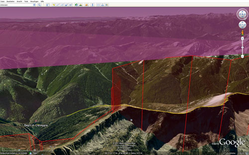
A Google Earth snapshot of Chrigel Maurer’s Red Bull X-Alps tracklog on 22 July 2011 – he bumped up into airspace and got a 24hr time penalty for it
This article was first published in issue 123 of Cross Country magazine, May 2009. It was commissioned by the magazine and Mark Graham, an engineer and long-time British paraglider pilot, spent several months and an XC season in Australia working on it.
The resulting article has formed the basis of discussion of GPS versus barometric altitude (an ongoing issue) at high levels in both the Paragliding World Cup Association and the FAI/CIVL. Both organisations use GPS altitude for scoring.
This article makes clear why Mark thinks we need to think again about how hang gliding and paragliding comps measure altitude and stop using GPS altitude to make critical decisions.
In the light of Task 1 of the cancelled Paragliding World Championships 2011 (32 pilots scored zero for busting up into airspace measured on GPS) and the ‘barometric v GPS altitude’ issue rearing its head in the Red Bull X-Alps 2011 we’re publishing it here online in full.
(Chrigel Maurer is reported to have been flying to barometric altitude, whereas the Live Tracking tracklog and scoring measures GPS altitude. Although at the time of publication the exact type of airspace infringement hadn’t been revealed, the issues raised are interesting for pilots. The article makes clear, proves, that the two can differ substantially: at least by 5%, often even more. Maurer is right to fly on barometric altitude; it’s the rest of the sport that is wrong!)
GPS AND ALTITUDE
Following the scoring mayhem of the 2008 Bulgaria World Cup Mark Graham argues that GPS altitude should not be used to avoid airspace or for scoring in competitions

Cross Country magazine issue 123, May/June 2009
Sopot, Bulgaria 2008. Task three of the Paragliding World Cup saw a meltdown as scorers found many pilots had infringed airspace and gave them zero points as a result. Some of the penalised pilots were adamant that they were innocent, and in some cases were subsequently proved to be correct.
One of the problems was misinterpretation of the information displayed on the flight instruments, and a misunderstanding of what was being recorded in the track log.
This article aims to highlight the differences between barometric altitude and geometric height (height above mean sea level) and explain the quirks of a variety of flight instruments. Once these points are understood then height restrictions may be defined clearly, and without ambiguity, and pilots will be able to read and interpret their instruments correctly.
The article concludes with some suggestions on how competition organisers can best declare height limits in competitions.
An example of how GPS and barometric readings can differ
GPS AND GEOMETRIC HEIGHT
In 1973 the USA decided to develop what we know today as the GPS system. This required 24 satellites for full functionality and the system became officially fully active in 1995. Each one is 20,200 km above the Earth and orbits it in 11 hours and 58 minutes. They travel at 3,900 m/s – so fast that Einstein’s theories of relativity mean the time of the clocks onboard appear different to those on Earth (not that this is important).
The GPS receiver that we carry needs to receive the signal from a minimum of three satellites to determine its two-dimensional location, or a minimum of four satellites to determine its three dimensional location. While we are flying it is quite normal to ‘see’ more satellites than this, resulting in a more accurate location.
Each of the satellites has an onboard atomic clock and transmits its position and the time to Earth: the fly-time of this transmission from the satellite to the Earth is about 70 milliseconds. Your GPS unit takes the time from each satellite and triangulates its location in space by calculating the difference in fly-time between satellites.
So, your GPS unit knows where the satellites are at any given time; it knows where it is (by triangulation); and it needs to tell you where you are relative to its model (which is selectable) of the Earth’s surface.
Your GPS unit has multiple models (datums) of the Earth in its memory.
The most commonly recognised global model is the World Geodetic System established in 1984 (WGS84). There are other datums that may be more accurate for individual countries, but in the hang and paragliding world we tend to use WGS84.
WGS84 defines the Earth as an ellipsoid: a squashed ball. This ellipsoid is a pretty good approximation to the mean sea level around the planet, but is recognised as having errors of between -100 m and +70 m with respect to the geoid, depending where you are on the planet.
The geoid is the best definition of mean sea level (MSL). It is defined by nps.gov as: “The particular equi-potential surface that coincides with mean sea level and that may be imagined to extend through the continents. This surface is everywhere perpendicular to the force of gravity.”
Picture the geoid as the ellipsoid with lumps on.

Diagram 1: How GPS height may vary depending on where you are, when using the WGS84 datum. In south India your GPS may show you 100 m lower than you are; in Iceland 70 m higher.
Diagram 1 (above) shows where the errors lie. In Europe the ellipsoid is about 50m above the geoid. In south India it is nearly 100m below.
Significantly, even though we select the WGS84 datum (ellipsoid), some GPSs add the geoid correction to give geometric height and some don’t. To work out the amount of error for where you live, use the online calculator for the ellipsoid to geoid height for any point on the globe at http://sps.unavco.org/geoid.
GPS ERRORS
There are additional errors involved in calculating GPS position.

Diagram 2: What contributes to horizontal GPS errors
The errors shown in Diagram 2 (above) exist in the X/Y axes (latitude and longitude); the vertical Z axis has around three times these errors due to the satellites’ position above the globe. Total accuracy is better than ±15 m in the horizontal, and about ±45 m in the vertical axis. If the satellite reception is poor these errors will increase, but while flying reception is usually good.
Different datums and use of the geoid or ellipsoid will give variable locations. This is an important point, and means it is essential that everyone in a competition uses the same datum.
There was a case in 2008, for example, where the scoring software used distances around the ellipsoid and one GPS instrument used the FAI sphere (a sphere of radius 6,371 km). The scoring program considered the pilot was outside the 3km cylinder by 3m, but his instrument declared him inside by 4.5 m.
Like what you’re reading? You will find plenty more like this inside Cross Country magazine. Here’s what some of our readers say:
“Honza Rejmanek’s new met article helped me enjoy a magical flight yesterday. Thank you for a wonderful publication” – Dan Corley, USA
“I love your magazine more than anything.” – Urs Haari, Switzerland
“Cross Country has a massive impact on pilots’ awareness, worldwide. Great job in inspiring and sharing knowledge!'” – Ben Kellett, New Zealand
To eliminate this problem there is a recommendation by the Paragliding World Cup, and in the CIVL FS scoring program, that 0.5% tolerance be set in the distance calculations of the scoring software.
Other errors can appear. For example, when the GPS displays height it is normally averaged over a few seconds. This leads to an accurate reading while stationary, but introduces a delay in the reading whilst climbing or sinking.
To counter this, satellite based augmentation systems are being developed for use in the commercial aviation sector and are already partially operational. WAAS, EGNOS and MSAS are all satellite based differential GPS systems that improve the accuracy of the GPS. The three systems are based in the US, Europe and Asia respectively and are compatible with each other. When WAAS was enabled my Garmin 76S worked in Australia in February this year, but it doesn’t yet work where I live in Spain.
BAROMETRIC ALTITUDE
The aviation industry has always used barometric pressure to measure altitude. Altimeters measure pressure and are calibrated to indicate that pressure as an altitude in feet or metres. The calibration assumes that the pressure drops at a standard rate as altitude is gained. We are interested in the altitude above ground level (AGL) or above mean sea level (AMSL) or with respect to the standard reference of 1013.25 hPa (Pressure Altitude, or PA). There is no evidence to suggest the industry will move to GPS altitude in the near future.
On any given day the pressure at mean sea level (MSL) will vary due to meteorological effects, and the pressure will reduce as altitude increases. Pressure is measured in hectoPascals (hPa) or millibars (mb), which are essentially the same. From sea level the pressure decreases with altitude at 27 ft/hPa, rising to 30 ft/hPa at 4,000 ft (1,220 m) and 40 ft/hPa at 15,000 ft (4,570 m). It is normal to assume 30 ft/hPa where we fly.

Formula 1
The International Civil Aviation Organisation (ICAO) defines a model formula for height, pressure and temperature (Formula 1, above) and defines standard pressure as 1013.25 hPa and standard temperature as 15°C at sea level. Flytec has derived height and pressure equations from the ICAO formula, and all altimeters are calibrated to meet this formula.
It should be noted that the altitude indicated by an altimeter is temperature compensated. For any given pressure the indicated altitude will be the same no matter what the temperature. This can give rise to a significant difference between the GPS height and the displayed barometric altitudes.
AIRSPACE
To remain safe and legal we fly according to Visual Flight Rules, and we have to avoid controlled airspace. Normally for a given area there is a transition layer, above which airspace will be defined at a certain flight level. Below the transition layer airspace is defined as altitude (ALT) AMSL.
For example, in Australia the transition layer starts at ALT 10,000 ft AMSL and finishes at FL110. In New Zealand and most of Asia the transition layer starts at ALT 11,000 ft AMSL and finishes at FL130. In the USA and Canada the transition layer starts at ALT 18,000 ft AMSL and finishes at FL180. In Europe, Middle East, Russia and China the transition layer varies, and can be as low as 3,000 ft AGL.
When flying below the transition layer, altimeters should be set to the local QNH (Query Nautical Height): the pressure at MSL for that area. The altimeter will indicate altitude AMSL. Restricted airspace below the transition layer will be expressed as altitude AMSL.
When flying above the transition layer, altimeters should be set to the standard pressure of 1013.25 hPa (or QNE, Query Nautical Elevation). The altimeter will indicate Pressure Altitude (PA).
To avoid confusion between Pressure Altitude and Altitude, PA generally has the last two zeroes removed and is then known as flight level: PA10000 is more commonly known as FL100. Restricted airspace above the transition layer will be expressed as a Flight Level.
It is essential to know the airspace restrictions in the area you are flying. It is possible to have a combination of Flight Level and Altitude restrictions during a flight.
DIFFERENCES BETWEEN BAROMETRIC AND GPS HEIGHT
Assuming that the GPS displays the geometric height above the geoid and that the signal reception is good then the GPS will display the height AMSL ±45 m. For any given geometric height, the indicated altitude of the altimeter (the one that defines airspace) will vary depending on the conditions of the day.
The problem with the altimeter’s indicated altitude is that it is calibrated assuming a standard day – that with increasing altitude the pressure drops at a standard rate. This assumption is not very accurate for two major reasons.
The first is if the temperature at sea level is anything other than 15°C then the rate of drop will not be standard. The second is the atmosphere usually has hot and cold layering making the rate of change of pressure non-uniform.
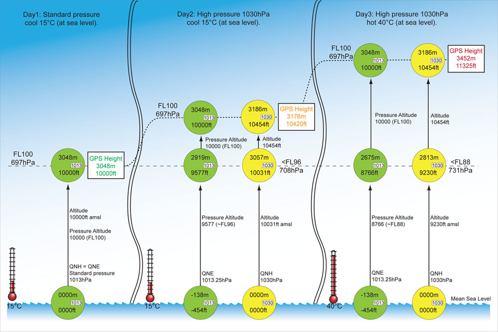
Figure 3: Day 1: is with QNH=standard pressure and the temperature is a standard 15°C. In this case FL100 is at an altitude of 10,000 ft AMSL because QNH = QNE = 1013.25 hPa. The GPS will measure a height of 10,000 ft above the geoid and everyone is happy. Day 2: has a high pressure system giving a QNH of 1030 hPa but it is still a cool 15°C at sea level. The green altimeter, set to QNE, will still indicate FL100 as 10,000 ft. At a pressure of 1030 hPa, the yellow altimeter will read 454 ft higher than the green altimeter at any altitude. Therefore the altitude indicated for FL100 will be 10,454 ft AMSL. The geometric height, as displayed by a GPS, will be 10,420 ft, at FL100. This geometric height is quite close to the 10,454 ft indicated by the altimeter set to QNH. For illustration purposes the geometric height of 10,000 ft, indicated by the yellow altimeter, equates to an altitude AMSL of 10,031 ft at a pressure of 708 hPa. Day 3: has a high pressure system giving a QNH of 1030 hPa but it is now a hot 40°C at sea level. The green and yellow altimeters will indicate the same as Day 2 because they are temperature compensated. However, 697 hPa (FL100) equates to a geometric (GPS) height of 11,325 ft. It has moved up. This geometric height is NOT close to the 10,454 ft indicated by the altimeter set to QNH. It is 871 ft (8%) higher. For illustration purposes the geometric height of 10,000 ft equates to 9,230 ft AMSL as indicated by the yellow altimeter at a pressure of 731 hPa.
Diagram 3 (click on it once and then again to see a bigger version) illustrates how Flight Levels change their height depending on the day. FL100 is used as an example and is always at 697 hPa. From this we see that a change in QNH pressure alone does not cause a large difference between GPS height and indicated altimeter altitude.
But a change in the MSL temperature does create a difference between GPS height and indicated altimeter altitude. The error introduced by the temperature change is 0.347% per 1°C above 15°C and -0.347% per 1°C below 15°C. The reason for this is that the ICAO formula assumes that the density of the air at a particular altitude is standard but in reality this density changes with temperature.
Does this theory work in reality? Diagram 4a, b and c (below) shows three paraglider flights made by Meredyth Malocsay in Australia in 2009 using a Flytec 6030. As it explains below, these flights show conclusively that there is a difference between GPS height and barometric altitude and that the difference can vary depending on the day – and it can be worse than the theoretical prediction.
DIAGRAM 4
These three paraglider flights were made in Australia by Meredyth Malocsay in February this year. She used a Flytec 6030 to record them. The first was four hours, the second three hours and the third three hours. The day temperature was about the same in each.

Diagram 4: Flight1

Diagram 4: Flight 2

Diagram 4: Flight 3
The technical bit
The GPS height (Y axis) is plotted against the Pressure Altitude (X axis) in each and the trend line (best fit line) automatically inserted by Excel. The trend line is a straight line with a general formula of y=mx+c. c is a constant offset in metres with the value of the height difference QNH – QNE on the day. m gives the steepness of the GPS height to Pressure Altitude line. If m is 1 then the GPS height increases at the same rate as the Pressure Altitude; we would like this in an ideal world but we are expecting m to increase as the temperature increases indicating the percentage error.
In Flight 1, c needs to be forced to a value of –40 m to account for the pressure of 1008 hPa whereas for Flights 2 and 3 c is zero because the day pressure happened to be 1013 hPa.
We are more interested in the m value. In Flight 1, m is 1.067, meaning that the GPS altitude is 6.7% higher than the Pressure Altitude. In Flight 2 the GPS altitude is 7.8% higher than the Pressure Altitude and in Flight 3 5.5%.
The theory
According to theory, the GPS altitude should be 5.2% higher than Pressure Altitude for a 15°C rise above standard. So in these examples reality is actually worse than the prediction. One explanation of this is that the atmosphere layering could have an influence. Almost certainly the atmosphere was not standard.
Notice that the graphs have a distribution around the trend line. This could be due to temperature and QNH changes throughout the duration of the flight. Also, due to the delay in the GPS height calculation, strong climbs will plot points slightly to the right and strong sink slightly to the left of the correct value, giving the line a marked thickness.
The conclusion
These flights show conclusively that there is a percentage difference between GPS height and barometric altitude and that the difference can vary depending on the day, and can be worse than the theoretical prediction. It would be good to repeat this using the same instrument on a 15°C day to see that the difference was closer to zero.
If you want to check this out, all the calculations, information and graphs for this are here.
INSTRUMENT DISPLAYS AND RECORDING
Detailed here and in Diagram 5 (below) are some of the instruments we use, what they display and what they record – this is not always the same thing.
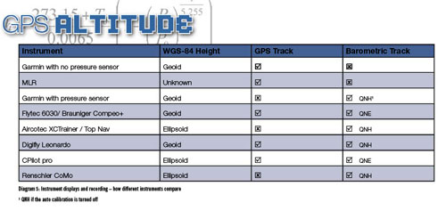
Diagram 5: Instrument displays and recording – how different instruments compare. (1. QNH is auto-calibration is turned off)
Garmin and MLR
Garmins always reference the height above the geoid, not the ellipsoid. Some Garmins without pressure sensors, and all MLRs, have no barometric capability at all. These instruments can only display and record GPS height.
Other Garmin GPSs with a pressure sensor are commonly used in free flight. The 76S and 76CS(X) and the 60CS(X) are popular first instruments.
The units display geometric height on the satellites page as ‘GPS Elevation’. Barometric elevation is displayed as ‘Elevation’ on the Elevation page and is a selectable field on all other pages. It is this barometric Elevation that is recorded in the track log.
Significantly, there are two methods of calibrating the barometric altimeter. In Auto calibration mode the altimeter is continually, but slowly, updated with the GPS height. When a Garmin 76S was, as an experiment, set 200 m too high it took 90 minutes to autocalibrate.
In effect the ‘Elevation’ displayed is a combination of GPS height and barometric altitude: it is the GPS height with the more sensitive changes of barometric pressure superimposed.
This combination of GPS and Altimeter height makes the information recorded ambiguous. It is probably best to leave autocalibration off and calibrate the altimeter manually.
In Manual calibration mode the pilot must set the height or pressure (QNH or QNE) for the day. After this, the Elevation displayed, and recorded in the track log, is based on the altimeter.
Worth noting for cross country league or competition pilots is that the altimeter can be calibrated at any time – including in flight.
Furthermore, the status of the altimeter and its calibration is not recorded in the track log. This means there is no way of knowing how, when or how often the instrument has been calibrated. Theoretically pilots could use them to cheat.
Flytec and Bräuniger
Flytec (6030, 6020, 5030 and 5020) and Bräuniger (Compeo and Competino series) are comprehensive flight computers that are combined GPS and altimeters.
They make available to the track log both GPS height referenced to the geoid, and barometric altitude referenced to standard pressure 1013.25 hPa.
The instrument has two barometric altimeters (alti1 and alti2) which can be independently set. User fields can also be set to display GPS height or barometric altitude.
The barometric altitude displayed can be set QNH or QNE. If the unit is set with QNH, then the track log still contains the information with respect to 1013.25 hPa (QNE).
It is good that all the instruments record altitude with respect to the same reference, but is not necessarily the actual AMSL for the day.
It is in fact the Pressure Altitude and is the information required for avoiding airspace flight above the transition layer. Final glide calculations are made using alti1 so this is best set to QNH.
Aircotec
The Aircotec XC Trainer and Top Navigator are also flight computers that display and record barometric pressure with respect to the QNH calibration.
In both instruments the altimeter can be manually calibrated to an altitude or QNH. Once the track log starts to record they cannot be re-calibrated without turning the instrument off.
The XC Trainer will normally automatically calibrate the altimeter when it is first switched on after acquiring the GPS position.
It will calibrate to the acquired GPS height above the ellipsoid. This calibration can be manually over-ridden before the track log starts to record. GPS height is not recorded in the track log.
Digifly
Digifly makes the Leonardo Pro flight computer. It records both GPS height and barometric altitude with respect to the QNH setting. The GPS height is referenced to the geoid. Alti1 is recorded and also used for the final glide calculator.
CPilot
The CPilot pro started life as software for Palm PDAs but now the hardware is being developed and will soon be launched. It is similar to the Flytecs in that it records both GPS height and Pressure Altitude (referenced to 1013.25 hPa). The GPS height is referenced to the ellipsoid.
Renschler
The Renschler CoMo OLC flight computer records the barometric altitude with respect to the QNH calibration. Alti2 is recorded and also used for the final glide calculations. Any GPS height information is with respect to the ellipsoid.
PROBLEMS IN COMPETITION
Altitude restrictions in force during a competition create headaches for everyone. Pilots wishing to do well will fly as close to the limits as possible and sometimes break them – deliberately or accidentally.
Competition organisers have to make sure rules are not broken and have to award penalties to hammer the point home that infringing airspace is dangerous, as well as unfair.
The FAI sporting code states: “The penalty for exceeding altitude limits that have either been specified at task briefing or published in airspace charts shall be a warning for the first infringement of less than 100 m by a pilot. For infringements greater than this or for subsequent infringements the pilot shall score zero for the day.”
The scorer of the competition needs to know the quirks of all the instruments presented at scoring. When the instrument and scoring program don’t agree on something it is a truly difficult situation to resolve. So how should we deal with height restrictions? Here are some suggestions.
Altitude AMSL restrictions
On days when the restrictions are altitude AMSL then all instruments should be set to the lowest predicted QNH for the day for the region of the task (Garmins must have altimeter calibration set to manual). This should be announced on the task board. MLRs (and Garmins with no pressure sensors) will only record GPS height and the onus is on these pilots to stay clear of airspace, knowing that the hotter the day the more the instruments will over-read.
As long as there is one instrument in the competition that gives a GPS/PA dual track, the scorer can extract the GPS height of the airspace restriction and verify all is ok for the GPS only instruments. The scorer will need to take the 1013.25 hPa derived traces (Flytecs/Bräunigers) and add the relevant 1013.25 – QNH * 27 ft/hPa to get the actual flight altitude. The scoring software could be made to automatically correct these traces using the QNH previously announced.
For the instruments that record pressure relative to QNH it may be necessary to stipulate that the track log is unbroken throughout the flight. It is feasible that the instrument can be switched off in flight and the altimeter calibration changed in order to cheat, though why anyone would want to is beyond me.
Flight Level restrictions
On days when the height restriction is FL there are two options.
Option 1: All instruments should be set to 1013.25 hPa, QNE. The barometric data recorded by all of the instruments will have a common 1013.25 hPa reference making life easier for the scorer. The instruments with only one altimeter display (eg the Aircotecs) will display Pressure Altitude (good for avoiding airspace) but there will be a problem with the final glide calculator because zero feet will not necessarily be at sea level.
Option 2: All instruments should be set to the lowest predicted QNH for the day as for the altitude AMSL case above. The Aircotecs in this case will not show Pressure Altitude and will need to fly remembering the QNE to QNH height difference for the day to calculate the altitude of the FL restriction. Those pilots with alti2 or a second altimeter would set that to QNE to be sure of the altitude of the FL restriction. The pilots with GPS only instruments will have the same problems as above. The scorer will have to take the QNH derived traces and subtract the QNH – QNE height for the day if there are airspace queries.
The second option is probably the more acceptable one. It means the same procedures are followed whether the height restriction is AMSL or FL and also in the rare case that there are both. Final glide calculators will operate correctly. It is quite normal to calibrate instruments (alti1) to QNH rather than QNE. It is then simple to calibrate alti2 to QNE.
GPS height could be used for both of the cases above. The competition organisers would have to declare the height restrictions with a good enough margin built-in that they don’t get it wrong and have a competition full of pilots infringing airspace (it could happen).
The problem instruments would be the ones that do not record GPS height: the majority of the Garmins with pressure sensors, Aircotecs and Renschlers.
CONCLUSIONS
In summary then, let me recap what we know:
– Barometric altitude is the standard used by the aviation industry.
– GPSs display altitude as a distance, whereas altimeters display altitude based on pressure measurements. The two are fundamentally different and you would expect them to differ. They more or less indicate the same at 15°C, but the gap widens as the atmosphere becomes non-standard: they differ more as the temperature moves away from the standard 15°C.
– GPSs give height with respect to either the geoid or the ellipsoid and this can differ by up to 100 m. There can be ± 45 m of errors on top of this with good signal reception, more with bad reception.
– The information available in the instruments’ track log varies between manufacturers.
– Not only must the pilot know what is being recorded in the track log, he must be able to see the values whilst flying.
– Scorers of competitions need to know what information is being recorded in the track log.
– Competition scorers also need to know whether GPS height or barometric altitude is being specified in the competition task.
– All of the flight computers are firmware driven. It should be possible to change the type of data logged if required.
This leads me to the conclusion that, as all other aircraft do, we should be using barometric pressure in competitions and cross country flying to avoid airspace. I do not like the idea of using GPS height for avoiding altitude restrictions.
Altitude restrictions are based on barometric pressure and it seems wrong to use something different. We are trying to avoid aircraft that are all using barometric instruments: can we guarantee that by using GPS height we will stay clear and safe?
Like what you’re reading? You will find plenty more like this inside Cross Country magazine. Here’s what some of our readers say:
“Honza Rejmanek’s new met article helped me enjoy a magical flight yesterday. Thank you for a wonderful publication” – Dan Corley, USA
“I love your magazine more than anything.” – Urs Haari, Switzerland
“Cross Country has a massive impact on pilots’ awareness, worldwide. Great job in inspiring and sharing knowledge!'” – Ben Kellett, New Zealand
I also think the 100m leeway for the first airspace infringement in a competition should be much less. It is the responsibility of the pilot to know what their instrument is displaying and recording. If the instrument shows the pilot is in airspace then the pilot should be penalised. The pilot needs to anticipate areas of strong lift and avoid airspace.
Additionally, track logs should be unbroken from take off to landing. A break in the track log could indicate that the instrument has been switched off and re-calibrated.
And finally, none of this is a problem if there are no altitude restrictions in the competition area or where you are flying.
>> Stay in touch. Get the latest news, safety notices and gear updates from our sports
ABOUT THE AUTHOR

Mark Graham
Mark Graham learned to paraglide in France and Scotland in 1992. He is a regular scorer at competitions, including the British and Ozone Chabre Opens and scored the 2009 World Hang Gliding Championships in Laragne. His personal best is 245km in Manilla. He lives in San Diego where he works as an electronics engineer.
He would like to thank Joerg Ewald, Garmin, Aircotec, Renschler, Digifly, Cpilot and especially Erich Lerch from Flytec for helping him compile this article. For an introduction to GPSs and competition flying see Mark’s article on the Fly Laragne website.
Understanding flight levels, altitude and height for pilots