Meteorology: Understanding Microbursts
11 November, 2015
Meteorologist Honza Rejmanek has been a paraglider pilot since 1993. He has competed in four Red Bull X-Alps, and came third in 2009. He lives in California. In his Meteorology column in issue 163 he wrote about microbursts.
In most cases you are likely to receive strange looks if you publicly express a fear of the sky falling. However, as pilots it is to our benefit to understand that under certain meteorological conditions there are particular parts of the sky that can indeed fall quite dramatically.
Under fair-weather thermalling conditions there is about as much sinking air as there is rising air. The rising air is concentrated in thermals and the sink tends to be more widespread.
When we see cumulonimbus clouds and their associated rain shafts it is easy to imagine that within these rain shafts there is a lot of air falling. Every droplet is dragging air down with it. A strong downdraught, narrower than 4km, slamming into the ground is referred to as a microburst.
Upon slamming into the ground this intense downdraught is forced to spread out in all directions, causing locally strong to severe winds. If there is wind aloft then some of this momentum gets transported down with falling rain too. In this case the strongest surface winds on the ground will be from the direction of the winds aloft.
Wet and dry microbursts
There are two types of microbursts. The one just discussed, associated with heavy rain, is called a wet microburst. Since the rain reaches the ground and the sky is stormy there is usually plenty of warning for the soaring pilot to land before being affected by the outflow of a wet microburst.
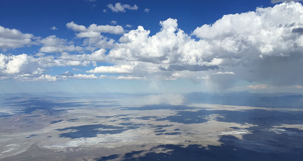
There is however a second type of microburst that can occur in drier climates, often on days when the sky looks epic with cloudbases well over 5,000msl. This more elusive microburst, which is depicted in the photo, is called a dry microburst. Any time we see high clouds with virga, or rain shafts that evaporate before they reach the ground, then we should keep in mind that there is a possibility of dry microbursts.
Why does the sky fall?
The reason the air falls so drastically is to do with the evaporative cooling of the air as the rain shaft evaporates. Often the clouds are up to 4,000m above ground level. The clouds might start dropping out even if they are not taller than they are wide. The initial precipitation might even be frozen.
Air in this shaft of precipitation is warming due to the fact that it is sinking and compressing. However, the melting of the frozen precipitation and the subsequent evaporation of the droplets acts to slow the rate of warming due to compression. With respect to its surrounding, the air is ever cooler and ever more negatively buoyant as it falls. Therefore it accelerates downward and mixes in drier and warmer air on its periphery. However, this air too is cooled as it helps evaporate the last of the rain shaft well before it reaches the ground.
[promobox]
Once the visible rain shaft disappears we are left with a very negatively buoyant shaft of air quickly falling towards the ground. The descent rate of this air can reach speeds of 15m/s or more in some cases. Locally, the sky is falling!
Microbursts in flight
In this photo taken on a cross-country flight in western Nevada we have the opportunity to witness what happens when the falling sky hits the ground. Thanks to the relatively fine dry soil, we can see the effect of this fast falling column of air slamming in to the surface.
A ring of dust (1) is lofted at the surface as the microburst strikes. We can see slight remnants of virga above this surface dust cloud (2). Further off to the right in the photo we can see other clouds starting to drop out and producing virga (3).
Most surface types might not be conducive to stirring up a cloud of dust when impacted by a microburst. Therefore despite being a dangerous meteorological phenomenon, a microburst is often invisible. The only clue that dry microbursts might be occurring is the presence of high-based cumulus clouds with virga on an otherwise dry day.
The danger of microbursts
Commercial aircraft crashes have occurred when encountering a microburst on final approach. This is a time when the aircraft is flying quite slowly. The sudden increase in headwind will cause an aircraft to pitch up. The unsuspecting pilot compensates by pitching the aircraft down and reducing throttle. As the aircraft flies through the centre of the microburst it experiences a lot of sink and then a strong tailwind. If the pilot is unable to increase throttle fast enough the aircraft might come up short and not reach the runway before impacting the ground. Fortunately, better understanding of microbursts by airline pilots, as well as wind profilers and shear detection systems at airports, have greatly reduced commercial airline crashes due to this phenomenon.
Conditions for microbursts
For soaring pilots it is important to recognise the conditions under which microbursts might exist. This would be a hot dry day with high-based cumulus clouds but enough mid-level moisture to cause them to grow large enough to start dropping out. Virga is certainly a strong warning sign. It is important however, not to mistake virga for mares’ tails, which is just the innocent fallout of ice crystals from altocumulus clouds, and might not even be caused by thermals.
If you enjoyed this sample article, perhaps you’d consider subscribing? A subscription is also a perfect gift for any pilot! Cross Country is a reader-supported international publication
Subscribe and receive 10 issue in print or digital, and we’ll also send you a Cross Country Wallet pre-loaded with 10 Euros to spend at xcshop.com