
This week's tip comes in the wake of the storm that has swept through much of northern Europe over the past couple of days. Winds of 170km/h caused disruption and damage. Broadcasters said much of the damage was caused by a 'sting jet' in the wake of the storm. But what is a sting jet?

Sting jets were identified following the 'hundred year storm' that swept through the UK in 1987. They are now known to be the cause of the most damaging winds in European windstorms.
Researchers found that the most damaging winds in low pressure areas occur in a very small region, perhaps only 50km across. This is 'mesoscale' – the same scale as seabreeze fronts or squall lines.
This area is close to the 'tail' of the 'head' of cloud that wraps around the centre of the low pressure.
This cloud, hooked like a scorpion's tail, gives the wind region its name.
The wind starts out three or four kilometres above the ground and descends over three or four hours.
Snow and rain falling into it evaporate and cool it as it descends.
This evaporative cooling means the air within the jet becoming denser – and faster.
This really is the low pressure's 'sting in the tail' – the part of the storm that will do the most damage when it hits the ground.
Wind speeds of more than 150km/h are associated with a sting jet.
Find out more from the UK Met Office
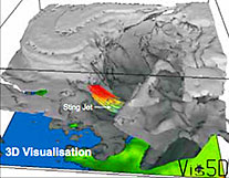
The sting in the tail.
Photo: UK Met Office

Join the family now by subscribing at
www.xcmag.com or call +44 (0) 1273 256 090
If you don't normally receive this newsletter sign up here
to have it delivered directly to your mailbox
Forward this to a friend ![]() share on Facebook
share on Facebook ![]() share on Twitter
share on Twitter